| TITLE | Qu’est-ce qu’une nation? |
| UNIT/ACTIVITY NO. | Étude d’un pays/Activity 1 |
| TOPIC | Geography, politics |
| FUNCTION | Description, definition, identification |
| FOCUS | Understanding concept of “country” and preparing for independent country study |
Teacher Instructions
| Step 1. | Before class, prepare Transparency 1 - the defining characteristics of a country. Also prepare Student Handouts 1, 2 and copies of blank maps of the region to be studied. |
| Step 2. |
In class, write this question on the board for students to see: Quelles sont les caractéristiques d’un pays? Using one of the following methods, allow students to brainstorm the possible characteristics or defining attributes of a nation. If the discussion is slow to start, ask the students: Qu’est-ce qui fait que les États-Unis sont un pays?
|
| Step 3. | Discuss the lists students have compiled by asking volunteers to share. Make a list on the board of student ideas. Sample questions: Quelles caractéristiques avez-vous en commun? Est-ce que vous êtes d’accord avec les autres groupes? Pourquoi ou pourquoi pas? |
| Step 4. | After the discussion, present Transparency 1. Explain that this list represents a compilation of geographers’ thinking about nations of the world. Many aspects can be disputed. After presenting the transparency, ask students to work in same groups or pairs to come up with five examples of countries that fit the defining attributes of a nation-state in the region you have chosen for study. Discuss the veracity of examples students provide. |
| Step 5. | Explain to students that they will become experts on one developing country within the region of study with the end result of writing or presenting about their country. Distribute countries. If students are working together in groups, either assign groups or allow students time to pick their own groups. Have one representative come to the front and draw a country name out of a hat. The same procedure can be used for students working individually. Draw student names out of a hat and ask students to choose a country from the region. |
| Step 6. | After students know their assigned country, distribute and go over Student Handouts 1 and 2 for homework. Explain that students will use their homework in the following activity. |
Materials
French-English dictionaries for group work, white paper (size 11x17) for maps. Map templates can be found at the following links.
http://geography.about.com/library/blank/blxindex.htm
http://www.eduplace.com/ss/maps/
Suggestions
For more background reading, try using Google with the search terms: “define: nation”.
Discuss with students the differences between developed and developing worlds: Quelles sont les différences principales entre un pays en voie de développement et un pays développé?
Depending on the sophistication of the class, students could also provide examples of non-nations or disputed territories. Examples can be found at: http://encarta.msn.com/text_701509043__1/Disputed_Areas.html
For the Pair-share and/or Numbered heads together activities in Step 2, provide dictionaries for new vocabulary words students might encounter and have students keep a list of these new words. As an alternative, start a list on the board during student discussion time of new vocabulary words.
Resources
Grand Atlas Hachette de Collectif
Atlas Hachette de Collectif
Le Grand Atlas pour le XXIe siècle de Atlas Géo Gallimard
Atlas mondial du développement durable de Anne-Marie Sacquet – Broché
Atlas des 193 Etats du monde : Cartes, statistiques et drapeaux de Patrick Mérienne
Atlas de l'alimentation dans le monde de Tim Lang, Erik Millstone
Atlas des désordres du monde : Points chauds et lignes de fracture de Michael Kidron
Pays et enfants du monde de Nathan
Atlas des femmes dans le monde de Joni Seager, Brigitte François
Peuples du monde de Collectif
Atlas pratique du Monde 2003 de Collectif
Atlas du nouvel état du monde de Dan Smith
World Facts and Figures by Victor Showers
United Nations Statistical Yearbook
Statistical Abstract of the World by Annmarie Muth
The Economist Pocket World in Figures, 2004 Edition by Economist Books
State of the World 2003 by Worldwatch Institute
Encyclopedia of the Third World by George Thomas Kurian, ed.
Women in the Third World : An Encyclopedia of Contemporary Issues by Nelly P. Stromquist
Worldmark Encyclopedia of the Nations by Shelly Dickey
The Encyclopedia of the Peoples of the World by Amiram Gonen
Handout 1
IMPORTANT! Attachez cette feuille à votre carte.
NOM:
DATE:
Vous devenez le spécialiste de votre pays, mais pas sans travail! Avant tout, il faut comprendre les aspects géopolitiques de votre pays. En utilisant les sites donnés, vous avez deux taches pour mieux comprendre votre pays.
La Carte. Vous créez une carte politique de votre pays avec la carte vierge que vous avez reçueen classe. N'oubliez pas les aspects suivants:
N’oubliez pas d’utiliser un stylo noir pour les pays et les villes, et un stylo bleu pour les.
Employez une couleur vive en utilisant des crayons de couleur.
Le Drapeau. Dessinez une reproduction du drapeau de votre pays à l’aide de feutres de couleur. Utilisez l’espace donné ci-dessous. Veuillez ensuite donner une brève description du drapeau.
Description:
Handout 2
SITES UTILES POUR LE PROJET
LES NATIONS UNIES
http://www.un.org/french/index.shtml
http://www.un.org/Pubs/CyberSchoolBus/french/index.asp
LES FONDS DES NATIONS UNIES POUR L’ENFANCE
INFORMATIONS, CARTES, ET STATISTIQUES
http://www.monde-diplomatique.fr/cartes/
http://www.educnet.education.fr/dossier/rechercher/carte2.htm
http://www.populationdata.net/
http://centraledesnations.com/nvengin.php
http://www.lemonde.fr/
http://www.cyberpresse.ca/reseau/monde/index2.html
http://www.lesclesjunior.com/Index.htm
http://news.google.fr/
http://fr.news.yahoo.com/
http://www.lefigaro.fr/
LES ÉTATS DU MONDE
http://www.quid.fr/monde.html
http://www.culture.gouv.fr/culture/dglf/ressources/pays/FRANCAIS.HTM
http://www.cia.gov/cia/publications/factbook/
DEPARTMENT OF STATE FOREIGN POLICY
http://www.state.gov/www/regions/internat.html
STATE DEPARTMENT BACKGROUND NOTES
http://www.state.gov/r/pa/ei/bgn/
HUMAN RIGHTS WATCH WORLD REPORTS
COUNTRY STUDIES/AREA HANDBOOKS
http://lcweb2.loc.gov/frd/cs/cshome.html
III. VISUAL AIDS FOR TEACHERS
Transparency 1
Click Here for PDF of Transparency 1
Transparency 2
The following is a text version of the Overhead and may be used as a student handout.
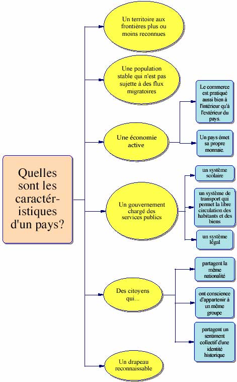
Quelles sont les caractéristiques d'un pays?
I. Un territoire aux frontières plus ou moins reconnues
II. Une population stable qui n'est pas sujett e à des flux migratoires
III. Une économie active
A. Le commerce est pratiqué aussi bien à l'intérieur qu'à l'extérieur du pays.
B. Un pays émet sa propre monnaie.
IV. Un gouvernement chargé des services publics
A. un système scolaire
B. un système de transport qui permet la libre circulation des habitants et des biens
C. un système légal
V. Des citoyens qui...
A. partagent la même nationalité
B. ont conscience d'appartenir à un même groupe
C. partagent un sentiment collectif d'une identité historique
VI. Un drapeau reconnaissable